Thanks.

Reflections and photos recording adventures in wild places

Don't worry about how to get there. Don't go searching all over the Internet for things to do while you're there. Don't busy yourself with maps and menus and matrices, for it is unlikely that any of those things will mean much once you are there. There are directions to this place – though I will not recount them here. And there are further specific place names and road numbers that may help in travel, but that is neither the goal or intent of this essay. Sonora can be found west and then south when traveling from Tucson – 'nuff said.
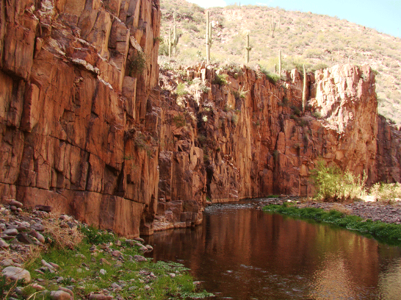
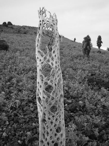
Within minutes of stepping from the car we were engulfed by the desert. Ocotillo in full leaf and bloom rose wildly on all sides, hemmed in by black basalt towers and domes. Craters and remnants of craters splashed with winter color created a lunar-like viewscapes to the west, while swirling desert playa dropped away to the east. In every direction was wilderness for as far as the eye could see.
On day two we learned about the craters by walking their long, elegant rims. Rarely is one afforded the privilege of a hike that describes a perfect circle, ending where you began without a step backward. On colorado we found a perfect nature-built trail of rock benches and steps. We weaved through indescribable formations of eroded tuff mixed with colored lava pours and chunky conglomerates. The geology of the place was confusing to the eye and mind, though it was impossible to not make an attempt to make sense of it. I wanted to capture the place with photos that I could share later. I wanted a way to prove that what I was seeing did indeed exist.
We were headed for a boat-access granite crag in the heart of Washington. With winter weather in the mountains heading to the Columbia Highlands was our only choice, and with the climbing guide swearing it was granite we just had to check this place out. The road was closed for construction when we got there so we rallied through the sand and grass and launched by carrying along an airport fence. I took a picture of the Gazetteer because we were now attemptimg a "new approach."
Banks Lake was deserted. We saw maybe four fishing boats from afar over the three days we were there. The weather was spotty but rarely did we have a problem with the winds
We were lost in a complex mess of granite domes and spits rising unnaturally out of the water. Banks Lake was never a lake, it was filled as part of the Grand Coulee Dam project. Looking at a map you begin to understand 'they flooded the Grand Coulee!'.
We had found the 'sandy beach camp' and the 'tall white granite face' - no thanks to the maps found within Central Washington Climbs - and also found a wide-selection of freshly bolted granite sport routes just minutes from the lakeside. With the binocs we scoped many mixed lines up the prow of what I believe is Post Modern Wall. With further route development potential and lots of good looking multi-pitch routes we will sure be back to this nice little cove camp - whatever you call it.
Scoured by warm wind and rain the winters snows are melting fast in the mountains around Spokane. In the St. Joe to the east the roads are nothing but mud. In the Selkirks to the north the transition to rain was slow and the highest elevation sit covered in classic snowy cement. Well, this week the snowpack will begin to fill the rivers and streams with meltwater, the sun will come out, and waterways will come alive. There is definitely still snow to ski but I find my mind dreaming up adventures in warmer wild places. Choppy deep green lakes and azure wave trains are just around the seasonal corner – I can feel it.
The historic and varied waterways that weave through this collection of inland NW ranges are now the top of the map pile. The Pend Oreille and the Coeur 'd Alene are massive drainages that sit east and northeast of Spokane and the sheer amount of water out there beckons summer exploration. Our early spring recon has begun though the drastic dreary weather has kept us scoping rivers from the shore and planning routes the old fashioned way: using maps gleaned from small town bookstores.
Then the sun came out. We went to the river. No one was there because it was cold. The trails were melted out and there were great blue heron and mallard ducks and beavers.
The swinging bridge above the rapids was sitting in a sliver of winter sun. It was warm and shiny and smelled like old railroad ties. You could feel the cold air coming off the river and mixing awkwardly with the sun warmed pines. Back in the tress, leaving the river, we dodged puddles of black ice, and it was bitter cold. The sun had gone down.The end of an era
Now that I'm settling for the winter I can take the time and look back through last seasons photos. IanOutThere came to an end as fast as our free-time summer when work at Naturalists At Large came crashing in from all sides. After a final last hurrah in the Tetons with Alok we made a 18 hour push from Jackson to Ventura to start our fall season. The photos from the season at NAL sum it all up... too busy for much more than work. Looks like I didn't even take my camera out for almost 5 weeks according to the date stamps.
My driving schedule was huge and so were the trips. I spent countless hours on the highway, alone in the cab of a box truck. I made a classic tour of California, including all the regular NAL haunts: Joshua Tree, Mono Lake, Point Reyes, Yuma and the Colorado River, all the while with Ventura in between. The state just seems to get bigger and bigger as the years go by.
I was happy to be part of the core crew on two of NAL's biggest, most logistically insane trips of the year. Highlights include 80 pounds of meatballs, on the river under only stars, and rally-driving overloaded box trucks through the sand. Let's just say supporting 300 people down a wild desert river is not a simple task.
So happy to have explored so many corners of California. The wild west is still wild.
IanOutThere
I've been telling people this: Those Washington Cascades are nothing like ours in Oregon. Yup, the volcanoes are there but the exploded remnants up north are bigger and more glaciated. Squeezed in from all directions throughout those big volcanoes are endless ranges coming from all directions. The approaches are wild with waterfalls and the mountains shoot up into every view. From the dense valleys to the icy summits its a long way up and the trailmakers' favorite tool is the switchback... and once your in the mountains there's granite and andesite and snow and ice to keep one busy for a lifetime.
Well, all this still holds true, and there's more. Yesterday we made a one-day ascent of Mount Daniel's 7,899 foot East Peak. It was our first notable journey into the Central Cascades this summer and we were quickly reminded of the sheer size of the range.
We climbed from 3:30am to the reach the peak by 10am. During the dark hours of the morning we climbed through pitch black forest to reach still ponds reflecting the morning clouds. Mount Stuart and the entire Enchantments sat to the east and we watched them fend off an early morning advance of desert cloud cover to leave us with a fantastic clear route to the summit.
Unfortunately the summer heat was immediately upon is and the snowfields turned to guck at once. We rushed up through the heat to beat the encroaching mountain melt-down. We climbed straight through the morning to make sure we could descend the steep snow before the sun had its full impact. The day was wild and hot and long and gave us a complete view of the many ranges laid out before us.
The Cascades, in their entirety, are all well within striking distance from Harvey Basecamp and from our Mt Daniel summit we saw we had a lot of work to do. I wished to be able to point of the names of each and every peak near and far, and for that, we must climb and explore across the range. Sometimes the only way to pick out and name the mountains in the distance is to have climbed them before. So, ...off we go.

Middle Sister is surely my favorite peak in the Oregon Cascades. Last weekend, the classic central sister made for a good day in Bend's local range. Eric, Tyler, and I had finally got our shit together, our schedules aligned and we made a midnight rendezvouz in Redmond. The drive through the night is a great part of these adventures, and from when we left Redmond at 3am we past not a single sole on the way to the Pole Creek trailhead.
With record hot temperatures forecasted for the day I was a little worried about the snow stability as the day warmed up. And indeed after returning home we heard of a late afternoon rescue on Hood the previous day. Somehow there are still mountaineers out there that don't understand the dangerous nature of a melting sno-cone. I had set in my head a 'summit-by' time for 11am. Knowing the steep snow step midway on the north ridge may pose a problem after a few hours at these temps we had move along before the inevitable melt-off began.

And move along we did. Stopping briefly and infrequently and keeping our eye on the prize as we blasted up the steep and forested east flanks of Middle Sister. The sun came out abruptly and everything was immediately hot. This was going to be a test of endurance in these temperatures. It reminded me of the Arizona desert – only with the added reflectivity of the snowfileds. Higher onto the mountain a slight breezed picked up and at the col I tossed on my shell and good my helmet and ice axe ready for action. We had very short food supplies between us – we ate the last of the pretzls and fruit snacks (I will pass by the story illuminating how this happen). We happily found the steep snowfield step well travelled with good steps kicked in and now starting to melt into rotten snow. The pitch was short and deposited us on the north shoulder which then relented in steepness, cross another low-angle snowfield, and plopped us onto the small summit.
Views in all directions. A little bit of whining a rejoicing. A sip of water and enjoying the summit breeze. Then reverse down the continually softening snow step and back to the col, which is now seeming like grand central station with a roped party descending, two couples ascending and a few solo hikers departing to the west. I attribute it to the general increase in recreators in Bend lately – the trailheads and notable backcountry areas are clearly seeing increased use (not to mention the Search and Rescue seeing a lot more boneheads lost in the reasonably straightforward Three Sisters Wilderness).
Once off the solar-oven snow fields and down through the thankfully shaded forests we reached the catchtrail heading back north to Pole Creek. The temperatures low on this west flank under scant lodgepole trees were truly opressive. I can recall no other time in Central Oregon where I have felt so blasted by heat and sun – my only comparison to this afternoon come from adventures in Mojave and Colorado desert lands. There is heat that can not be escaped, dry wind that sucks the moisture from your pores, and shade to thin to help. Our final trail miles were as all final trails mountaineering-in-day trips should be: brutal, hot, and way longer than they seemed going in. What a great trip!
When we first arrived in Zion on May 15th the rivers were high and flowing thick with red sand. The desert sun was still tempered by the spring rains and everywhere was exploding with wildflowers. We counted up to fifteen different species in bloom on one trip into the Escalante. The winds were present too. We had read about the tortuous May winds of the desert in a couple of guidebooks but nothing could have prepared us. The desert is an exposed place and a strong wind just adds to the desolation and intensity of the landscape. There was no help from vegetation so you had to turn to the geology for reprieve. It is a rare day when reading the wind on the landscape in needed for your daily comfort and survival. Finding a spot out of the wind does not to prove to be as easy as finding a spot out of the sun for example – having the telltale sign of shade as your guide. With wind it is more subtle, you hike across a wide sand-blown valley to an alcove that looks great and its the windiest place out there. Where there is less wind, the sand drops out of the heavy air and onto you and into your eyes. There is no escaping the wind.
By June the desert was feeling regular again. It was hot, but not unbearable, there were flowers, but only those guarded by canyon walls, and clear, spring-fed streams replaced silty torrents. It was the quality and nature of the watercourses and the water within them that changed the most for us. The amount of silt carried in the creeks seemed to change the colors of the whole canyon. First torrential snow-fed maroon cream, then blue glacier-like pools and iridescent falls, then crystal clear mirror-like pools that reflected the ripples into magical orbs. The combinations of colors and light are infinite in a water-filled desert canyon. After a month of day-to-day experiences within these rare, remote canyons the seasonal variations that changed the entire nature the of the beast became apparent. In Escalante, where water is harder to come by than in Zion, the wildflowers and shrubs seemed to respond to the intensifying summer on a daily basis, tightening up their skins almost before your eyes. Every component of the desert wilderness is invariably teased or shaped by the Earth's most precious resource. Its hard not to notice the immediate and ancient role of running water in the landscapes' creation. We were there too, following its courses downwards towards the all-encompassing Colorado and learning about the coming and going of the land.

The dragon came from Escalante. He, or she, lived in a grand slot canyon that entered into the heart of the mighty river. In times past the mighty river flowed strong and thick into the even mightier Colorado. Nowadays it was summer, and 2010, and the once formidiable Escalante now trickled into the cold and narrow lake arm that swallowed it without notice.
In the canyon that he, or she, now resides in, is a Grand Cathedral. The alcove holds a spring and large boulders that have fallen from above. It is surrounded on all sides by towering red walls. The walls fortify and protect dark arches that make up the roof of the alcove. These ledges, dark and wet, make good homes for dragons.

After the rivers ran still and the mightiest Colorado backed up behind the dams the dragon found he, or she, no longer gained the satisfaction from cursing through the long river canyon from sea to mountain crest as he, or she, did when the water flowed strong. With wings wide he, or she, would bank from wall to mighty wall and follow the boisterous froth in its entirety, which was reportedly an easy feat for a dragon. Once the heavy waters stilled, parts of mountains dropped from them to the bottom of the not-so-mighty ponds, and with the settlement came that of the dragon. Clear, cool water now seeped from the bottom edge of the concrete spring and filled the former channel with sharp jumpy water – no place for a dragon regardless.
Its easy to see why he, or she, would pick such a place to settle. The slot would be a good place to hold up for the remaining long life of a dragon. The tourists aren't much of a bother and, for a dragon, the climate in surprisingly mild. The sun there is strong and reassuring and the ferns have many day to day usefulnesses. The canyon is named on maps but the name can not be said here. The dragon wouldn't like it published. He, or she, has asked nicely, and considering all that he, or she, has been through.